White Chalk Horses, Cerne Abbas Giant & Paracas Candelabra
As you fly over the south of England, gigantic figures appear against the backdrop of green hills. They were laid bare by removing the tufts of grass that covered the underlying layer of limestone. They evoke two main subjects: man and horse. According to archaeologists, prehistoric Brittany had a large number of these figures which were then covered by vegetation. However, some of them have survived to this day. Ancient coins and other historical evidence found on this site suggest that at least two of these figures - the White Horse of Uffington and the Giant of Cerne Abbas - date from the beginning of our era, when the Celts populated Great Britain.
The Westbury White Horse
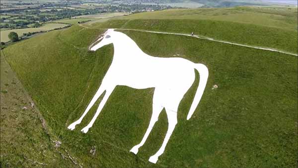
It is a chalky figure carved into a hillside in Salisbury Plain. It is said to be the work of a gentleman from the region who, in 1778, decided to take up the course of an ancient horse that was already engraved on his land.
Unfortunately, his intervention erased a much more interesting figure: indeed, a drawing of 1772 shows the primitive image of a horse with a thin and slender body, with a long and slender tail drawing a sort of crescent moon, and a huge eye on the top of its head. The dating of the original drawing remains a mystery: some claim that it is the work of the Celts, others that it was made to commemorate the victory of King Alfred over the Danes in 878, still others that it is a hoax carried out in the 18th century.
The Uffington White Horse
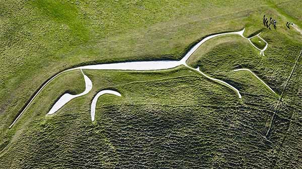
The superb Uffington White Horse, named after a village in Berkshire, about 100 kilometers west of London, appears to gallop up the crest of the hill for about 150 meters. As long as a football field, this stylized steed is a formidable example of primitive art and stands out with its clear contours against the green of the surrounding countryside.
Like other similar figures, he stands near an ancient fortress, on top of a hill. According to specialists, he is a tribal figure intended to frighten enemies. An even more fascinating hypothesis is suggested by the proximity of Dragon Hill - a plateau a little further north - where, according to legend, Saint George, the patron saint of England, killed the famous dragon. Archaeologists claim that by the time they converted to Christianity, Celts in the western parts of England may have equated the figure of St. George with that of a pagan demigod symbolized by the horse. It could also be that the horse originally represents the dragon. Experts point out that the jaw resembles a beak, and that the very shape of this figure would evoke a reptile.
These figures have always been of great importance in the life of the local population, because they reflect a deep link with the land and an ancestral spiritual tradition. According to an oral tradition dating back to the 7th century, every seven years on the day of Pentecost - the seventh Sunday after Easter - the inhabitants of the village of Uffington gathered here to restore the figure of the great white horse by mowing down the vegetation covering it.
Then they celebrated the event by feasting until late in the night. The last of these “hobbies”, as they were called, dates back to 1857.
The Giant of Cerne Abbas
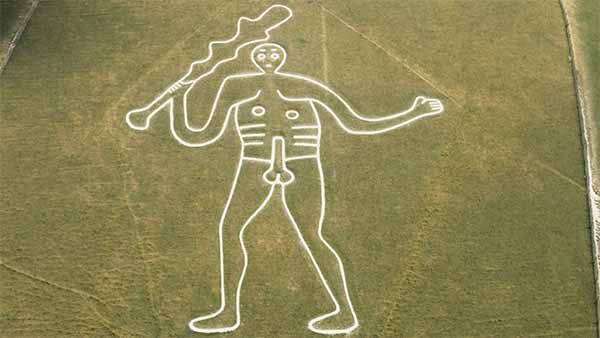
120 kilometers from Uffington's White Horse, the Giant of Cerne Abbas lies on the flank atop a hill in Dorset. This figure, which is no less than 55 meters long, seems to wave an enormous club; he has been famous for centuries for his ostentatious nudity. Some researchers associate this giant with the cult of Hercules, which was particularly widespread during the time of the Roman Emperor Commodus at the end of the 2nd century AD. According to other hypotheses, it would be either the Celtic god Nodens, or the central figure of a pagan cult of fertility which would have been perpetuated through the dances of calends of May, after the conversion, in the 7th century, of the population to Christianity.
The Long Man of Wilmington
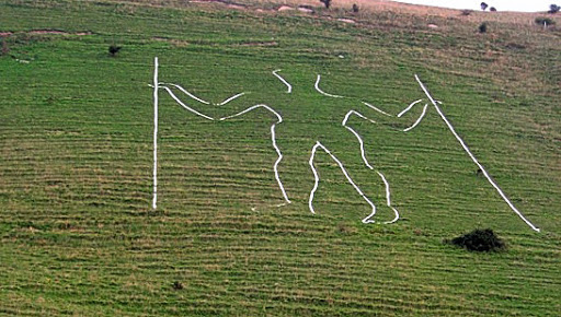
It looks like a gigantic figure of a man 70 meters tall, holding a long stick in each hand. Engraved on the western slope of Windover Hill, near Wilmington, Sussex, its dating is uncertain, as its present form dates from the restoration in 1874. Hypotheses about its identity are numerous and vary from the figure of a giant local to that of Saint Paul, through a Roman soldier, a Saxon mower, or even a sort of prehistoric topographer using sticks for his surveys. Either way, it is very likely that the work was done 2,000 to 2,500 years ago.
The Paracas Candelabra
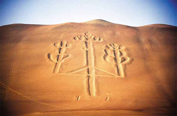
The Candelabra of the Andes can be seen when arriving in Paracas by sea. Even today, "el Candelabro" dominates the bay without having revealed its secrets, neither that of its meaning, nor that of its origins. Dug in the sand, it is characterized by precise dimensions and orientation: it measures 183 meters, the central ditch is 5 meters wide, and its depth varies between 50 and 60 centimeters. It is oriented along a north-west / south-east axis. We do not know anything about the time and the culture from which it is the result and we do not know whether it is related to the observation of the stars. Over the years, pretty much all kinds of assumptions have been made about the Paracas Candelabra, like the Nazca lines. Some believe that these lines were used for choreography or for running races, if not to stretch the threads before weaving them. One researcher went so far as to assume that since the construction of these routes required a considerable labor force, it served to slow down population growth, given the environmental poverty of natural resources.
A sign from space?
In the late 1960s, astronomer Gerald Hawkins closely investigated the possibility of a relationship between ninety-three features of this site and the position of stars over the past seven millennia. Result: Hawkins did not find any significant correlation.
Although the sites of Nazca and that of the Paracas Candelabra are not so close geographically, attempts to explain their origins show some commonalities. Erich von Däniken was one of the first to relate the Nazca signs to extraterrestrial visits: in this case, these plots would have served as real "landing strips" for spacecraft, while the Candelabra of the Andes would have served as "lighthouse ” allowing celestial navigators to locate themselves. The gigantic drawings of the area were probably meant to be seen from the sky, knowing however that such a view was impossible for the people of the time. In a completely different perspective, some claim that the Paracas Candelabra is the work of pre-Columbian civilizations, while others see it more as a landmark used by pirate ships of the 16th and 17th centuries.
Peak under the Southern Cross
According to the writer Graham Hancock, the design of the Paracas Candelabra could be 2,000 years old and be the product of the same people who made the Nazca lines, in other words the homonymous civilization that lived between the 2nd century BC and the 6th of our era. Also, the Candelabra of the Andes would evoke the celestial vault insofar as the design is very close to the north-south axis, the meridian of the sky and the great dividing line that astronomers of all cultures take into account in their observations of celestial movements. “El Candelabro” is only visible from the north. Computer simulations would show that at midnight, on the day of the spring equinox 2,000 years ago, the constellation of the Southern Cross was on the southern meridian at an elevation of 52 degrees. The observer approaching the coast by boat, 1 kilometer from the Paracas Candelabra, would have seen the Southern Cross as though suspended in the sky, steeply on this enigmatic route. This constellation, unknown to European sailors until the 16th century, was on the other hand very well known to astronomer priests of the Andes. The Southern Cross crosses the Milky Way and is in the region of the sky where the Incas located the entrance to the kingdom of the dead. In addition, it is close to two nebulae where this people recognized a fox figure and a llama, knowing that since the dawn of time, Andean traditions have associated these “animals of the sky” with the legendary flood that destroyed the Earth, a flood that would have been announced to humanity by a particular celestial conjunction.
Leys
Other images of horses and giants engraved on the English hills date back to the 18th and 19th centuries: they were produced by the local gentry for purely decorative purposes. Some of these figures are found near an ancient road network of straight lines called "leys" - from the Saxon word meaning "arable land" - which crisscross the English countryside, linking megaliths, burial mounds and other important sites. These "leys" correspond to lines of force capable of emitting a mysterious geophysical energy.
Paracas culture
260 kilometers from Lima, Peru, is the Paracas Natural Park, which still retains traces of the populations who lived there from the 3rd millennium BC. Among other remains, many tombs and their funerary furnishings stand out and are the subject of study and research since a relatively short time. Indeed, it was only in 1925 that archaeologist Julio C. Tello began systematic excavations at the site. Fortunately, the very dry climate of the region has allowed many mummies to remain in an excellent state of preservation. According to Tello's studies, it was around 650 BC that the so-called “Paracas” civilization began to develop, knowing that around the year 200 AD, it would take the name of “Nazca”. This in turn will be supplanted, nearly a thousand years later, by the Andean culture of Tiahuanaco-Huari.


