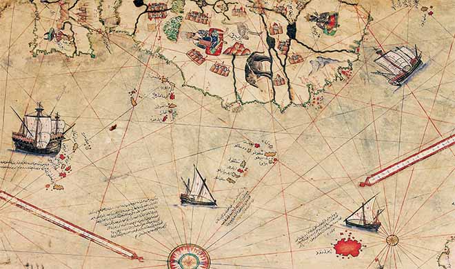
The Piri Reis Map of 1513
A Timeless Document

In around 1510, the Turkish admiral Piri Reis captured a large number of prisoners during a naval battle. One of these prisoners prides himself on having sailed with Christopher Columbus on his journey to the New World and claims that he knew perfectly well where he was going, because he had extremely old nautical charts. Fortunately, he himself kept a copy which he gave to the Turkish admiral. This is the story - seemingly whimsical in appearance - made by the famous admiral, who was in possession of one of the most enigmatic nautical charts in history: the Piri Reis map. This map will be found in 1931 after years of oblivion.
A disconcerting testimony
The Piri Reis map, as it is now called, is an exceptional document insofar as it seems to show the coastal lines of West Africa and those of the north and south of the American continent at a time when these lands were unknown. The Piri Reis map would also locate the Falkland Islands with great precision, knowing that they were only discovered in 1592. Is this pure chance?
In 1953, the United States Department of Navy looked at this famous Piri Reis map: the mystery seemed to thicken. The drawn regions have strange proportions and at the bottom of the map coasts which do not correspond to any known land are reported. The conclusions of the American navy are disconcerting to say the least: the Piri Reis map would have been drawn thanks to a very sophisticated method of projection (the process used to represent the planet on a flat surface) which supposes advanced technological knowledge and especially observation from the sky. Another surprising aspect: the latitude and longitude values seem to be faithfully reported, even though they were not yet used at the time.
But there is more. The sides drawn at the bottom of the Piri Reis map seem to correspond to Queen Maud Land, in Antarctica, except that they are represented without the 1.5 km thick ice crust that already covered the South Pole in 1513. The report ends with this sentence: “We do not know how the data shown on this map can be reconciled with the state of geographic knowledge in 1513.”
Divergent assumptions
According to a recent hypothesis confirmed by on-site studies, the last era in which Antarctica was not covered with ice ended 6,000 years ago. Consequently, the question is not only to know by what mystery a map of 1513 traces the contours of a continent discovered only in 1818, but also and especially to know how these lands could have been represented at a stage and in a state that ended 6,000 years ago.
But this is only one of the hypotheses put forward. In most cases, experts agree that the Piri Reis map contains a large number of errors, and that the identification of Antarctica with the coasts drawn to the south is not as obvious as the United States Navy would like. The mystery therefore remains intact.
Rivers of discord
The Piri Reis map is said to contain errors that contribute to the controversy over it. For example, if the course of the Amazon River, imposing by its length, is traced twice on the map, the Orinoco River does not appear there. Some believe that the error is due to the fact that the admiral would have copied the course of the Amazon River from two different maps. In the waters of one of these rivers is drawn the Marajo Island, absent in the other. From then on, would Piri Reis be inspired by a map from 13,000 years ago, when the islet was still attached to the continent and the Orinoco River did not yet exist? Which only fuels the controversy over the merits of the map ...


